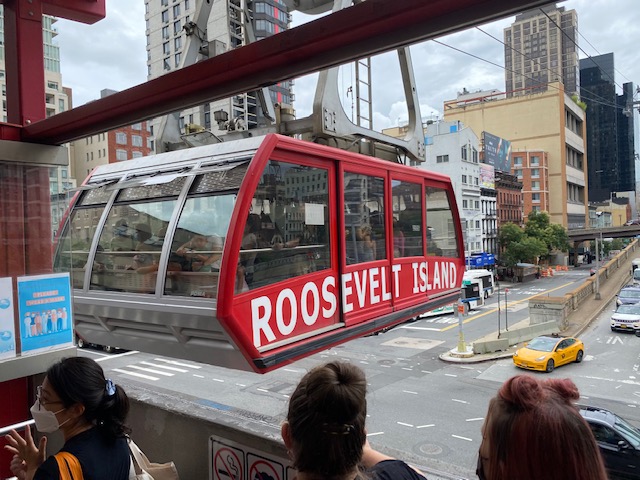
Roosevelt Island Tram And Red Bus Now On Google Maps In Test Phase, Goal To Launch Permanently By February Says Former Resident Alex Bores Who Spearheaded The Initiative - Great News, But When Will MTA's OMNY System Be Installed On Tram?
Roosevelt Island residents often think of themselves as the forgotten stepchild of NYC - services offered in other NYC neighborhoods are either not available here or we're waiting at the back of the line for them, but that has slowly started to change recently.
For example, Roosevelt Island residents and visitors have asked for years when
the Roosevelt Island Tram will be included in Google Maps? Now we know. As
some residents have discovered recently, the Roosevelt Island Tram is
currently on
Google Maps in a test phase.
And the Red Bus shows up in directions😳 This is huge 😂👏🏾👏🏾
— Nameliest of the Norms (@NamelyNorm) January 14, 2022
How did this happen? The initiative to get the Roosevelt Island Tram on Google Maps was spearheaded by Alex Bores, a former Roosevelt Island resident with a Masters in Computer Science and currently Democratic Party 76 Assembly District Leader (which includes Roosevelt Island).The cats out of the bag! Proud to have worked with @kimmosc, @SeawrightForNY , and @RepMaloney to get the Tram and Red Busses on Google maps! https://t.co/0z4m7YigLA
— Alex Bores (@AlexBores) January 14, 2022
Mr Bores reports:
The Tram and Red Busses Launch on Google Maps
The Roosevelt Island Tram and Red Busses (including Octagon Express) are now in testing on Google Maps. Residents and visitors can look up transit directions the same way they look up the subway.
Google integrates around 120,000 different transit systems worldwide. This includes many different transportation sources around Roosevelt Island, including the subway, the Hornblower ferries, and Citi Bikes, but until now, did not include the tram or busses.I noticed the tram was not on Google Maps when a friend tried to visit me. When he saw that Google’s directions did not suggest the Tram, he assumed it wasn’t running. I teamed up with Assembly Member Rebeca Seawright and the Roosevelt Island Operating Corp (RIOC) to accurately represent the schedule, and then coded it into the technical format that Google and other map providers use to show schedules.
Roosevelt Island has thriving businesses, but too few New Yorkers know how accessible the Island is. Instead of showing a route that requires people to wait up to 30 minutes for the Q102, visitors will also see the red busses running every 7-15 minutes. For residents that want to visit Manhattan destinations like the Trader Joe’s right across the river, Google Maps now shows the 13 minutes the trip takes by tram instead of 19 minutes via the F train.
The schedule is still in testing, so the feed may change or be temporarily unavailable in the future. RIOC will provide updates to the schedule over time. The schedule is static, meaning it shows the planned schedule instead of tracking the real-time location of any busses or tram cabins. The goal is to launch it permanently by the end of February, as well as to have it appear on Bing Maps and Apple Maps (where currently the tram appears but not the busses).“The Roosevelt Island Tram has been a relied upon and heavily used mode of transportation that has been serving New Yorkers for the past 45 years and carries about 6,000 people per day between the island and Manhattan,” said Representative Carolyn Maloney. “Despite all that the tram contributes to our community, it has never appeared on Google Maps. By listing it as an option and displaying its schedule on Google Maps, Roosevelt Islanders and visitors alike will be able to better take advantage of this eco-friendly transportation option. I am thrilled that District Leader Alex Bores and island residents successfully campaigned to correct this oversight.”
The team used software built by the National Rural Transit Assistance Program (NRTAP) program under the federal Department of Transportation. The free software makes it easier for smaller transit agencies to create and change their schedules in ways that Google and other map providers can ingest.
District Leader Kim Moscaritolo, who helped start the project, said, “I’ve spent many years traveling to and from Roosevelt Island, and having the tram on Google maps is long overdue! Now, all residents and visitors will be able to plan their trips easily and efficiently.”
“Roosevelt Islanders rely on the tram and Red Bus to transverse the City,” said Assembly Member Rebecca Seawright. “I am pleased to have been a part of getting these critical transportation options integrated into Google Maps. I commend our local District Leader Alex Bores for working with RIOC to make this integration possible for Roosevelt Islanders and visitors to travel with ease.”
Next project is to get the Roosevelt Island Tram on the MTA's OMNY system.wait really??? I literally have a message I copy and paste to send any friends when they come out to visit lmao pic.twitter.com/VRz6Hk99xj
— 😷 (@indigogurt) January 14, 2022
@MTA when are you bringing OMNY to the Roosevelt Island tram? It's an important part of a daily commute for our community, and I'd love to use OMNY
— Stephanie Diaz (@climate_soccer) January 13, 2022
I thought it was supposed to be installed by the end of 2021. I guess @RIOCny forgot.
— Μiguel (@LTEstyles) January 13, 2022


0 comments :
Post a Comment